About
Geographical position
The climate of the region. Main climate types. Significance of the region’s climate
from the point of view of agriculture, health resort and tourism
The geographical position and mountainous relief of the region greatly influenced on formation of complex climate conditions in vertical droughty area, as well as on density of river network and richness of soil- vegetation cover. Approximately 25 million years ago, there was a damp subtropical marine climate in the territory of the region.
Torrential downpours and warm temperature caused development of dense evergreen forest cover in this region. Here, 1 million years before, there was a climate similar to one existing in present Mediterranean coasts and this climate condition was favorable for development of multifoliate evergreen vegetation and plants throwing away their leaves in dry summer season. During the last continental ice age took part in 10-12 thousand years before, high and medium mountainous zones of the region were covered with glaciers, afterwards at the result of warming of the climate, the glaciers, having thawed, became smaller and got closer to the modern borders.
The geographical position according to the equator, amount of solar radiation (common and straight), variety of relief and surface cover, as well as the character of the air masses entering to the territory plays a great role in formation of the modern climate of Gabala. All the above remarked climate forming factors influence on the amount and diverse distribution of temperature and rainfall in the territory of the region. Since 1936, air and climate conditions of Gabala are studied in meteorological station functioning in the city and in Nij settlement for a while. Perennial average January temperature in Gabala changes from 0 0 to 14 0, and July temperature from +24 0 to 2 0 correspondingly. Annual average temperature changes from +10 0 - + 12 0 in the south to 0 0 - - 2 0 in the north.
According to academician B.A.Budagov, the hottest place in the region is observed in the direction of Gushlar-Kurd-Bayramovka villages and maximum temperature here reaches 410-420. Minimum temperature in the region is remarked in Bazarduzu peak (4466 m) – it fell down to – 50 0.
Distribution of atmospheric precipitation in the territory of the region changes from the south to the north. Minimum annual rainfall falls in the south of Hajalli and Malikli plains and it reaches 350-400 mm, maximum annual rainfall falls in the north on 1500-200 meter height and reaches 1200-1300 mm. During the conducted observations it was determined that 25-30 % of annual rainfall falling to the territory of the region showers in May –June months.
When characterizing the climate of Gabala region on the base of the climate of the Caucasus Mountains, I.V.Figorovskiy (1926) stated that the climate in Gabala is very complex and changes from dry subtropical climate to the mountainous tundra climate. Generally, the territory of the region refers to the second zone in Azerbaijan (Sheki-Zagatala) after Lenkoran- Zagatala zone and is located in a passage zone from subtropical to mild climate zone. Nine climate types out of 13 existing ones on the Earth exist in Azerbaijan, and four of them are in Gabala region.
The scholars- climatologists (I.V.Figorovskiy and A.M.Shikhlinskiy) divided Gabala territory into the following climate types:
1. Mild warm climate with dry winter- this climate type encompassing the south part of the region is characterized with a little rainfall and dry warmness. This climate type covering low mountains beginning from the border of Aghdash –Goychay regions and Hajalli Malikli plains is much similar to the Mediterranean marine subtropical climate by character.
2. Mild warm climate with approximately equal distribution of rainfall- is characterized with abundant rainfall and a short term of the warm season. It covers mainly Alazan – Haftaran valley and the north part of the region located on 1100-1500 m height. Here distribution of the rainfall among the seasons is equal. However, its annual amount reaches maximum range (1200-1300 mm) over the region. In addition, this climate type differs from the previous one with the temperature regime.
3. Cold climate type with abundant rainfall during all seasons – It is characteristic for the territories beginning from high border of medium mountainous area till the areas located on 1500-2700 m height from the ocean level.
4. Mountainous tundra climate type- encompasses the area located on 2700 m height from the ocean level. There are abundant rainfall and cold weather here all seasons long. High mountain peaks of the region are covered with snow and glacier and are distinguished with typical mountainous arctic climate conditions.
Therefore, the climate types remarked in the territory of the region spreading from the south to the north over the vertical zones seriously differ from one another with temperature and amount of the rainfall, as well as with alternation of the seasons.
Spring’s coming to Savalan and Gushlar villages are observed 25-30 days earlier than in Laza (1350 m) and Gamarvan (1125 m) villages which are located on the highest points of the region. In autumn and winter seasons it is vice versa. Characteristic climate of Gabala had historically created favorable conditions for the development of varied agriculture here.
Agro climatology of Gabala has thoroughly been studied by the Institute of Geography of Academy of Science of Azerbaijan Republic in the middle of 70th years and wide information on the agro-climate recourses of the region has been given in different scientific sources. The main indicators determining the agro-climate of the region are as follows. Annual average temperature of the weather is 10.6 0, absolute minimum temperature reaches 140, absolute maximum temperature reaches +37 0 – 41 0 and the temperature on the surface of the soil reaches +13 0.
The amount of annual average rainfall is 1027 mm, evaporation is 680 mm and coefficient of humidity is more than one (1.5), relative humidity is 78%. Mountain – valley winds are observed in the territory of the region in connection with the ogrographic conditions. It is remarked that average speed of the wind is 0.8 m/sec., hard wind blowing per a year lasts for 3 days, the days with “agh yel” (“white wind”) lasts for 8 days, hailing days are observed to last for about two days.
Snow cover in the region remains up to 45 days. The first autumn frost is observed to take place in the second decade of December and January, and the last spring frost is observed on April 8. Annual average temperatures more than 5 0 reaches 3769 0, whereas (active) temperatures more than 10 0 reaches only 3.361 0. Amount of solar warmth (energy) falling to 1 sm² on the foot of the mountains reaches 123.6 kkal, whereas on the high mountainous areas its growth (as the cloudiness is decreased) is observed.
Amount of annual average days without frost is 241 days (minimum 208, maximum 287 days), the quantity of days during the vegetation period when the temperature above 5 0 is observed is 265 days and quantity of the days with the temperature above 10 0 reaches up to 198 days.
Professor A.J.Ayyubov, during agro-climate regionalization (1978) of Azerbaijan Republic, divided the south slope of the Great Caucasus area, where Gabala region refers, into six agro-climate regions. Each above-mentioned region has a particular place and significance in the development of agricultural fields.
Relief, geological structure
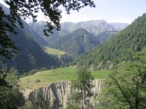
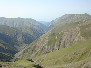
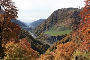
The relief of the region is mountainous and begins from the highlands of the South slope of the north part of the Caucasus spreading to the central part of Alazan-Haftaran (Ganikh-Ayrichay) valley, the south part spreads from frontal highlands of Ajinohur to Gabala high plateau and the south border of this high plateau substitutes oragraphic units of Surkhaykhan (Akhar-Bakhar) chain of mountains up to watershed.
Saral, Choban baba, Muchug, Tufan and Aghbulag branches referring to this watershed encompasses the territory of the region as a chain from the west to the east.
1. Saral branch – it lasts from Ragdan height up to Filfichay and Tikanlichay. This branch alters from 2000 m from the sea level (Koshukar mountain) to 1000 m in the south.
2. Rustambaz branch – It separates from the Salavat river and is divided into two branches, the branch going to the west is called Safaryatag, whereas the one going to the east is called Rustambaz Salavat mountains (branches).
3. Mujug branch – Beginning from the south-west of the Salavat pass (2896 m), it is located between Vandamchay and Damiraparanchay.
4. Aghbulag branch – It encompasses the area beginning from Garaburghu mountains of Ismayilli region to the eastern (left) banks of the Vandamchay river. The territory of Gabala region is divided into three areas from geomorphologic point of view:
1. The mountainous area undergone to denudation - covers the north part ( up to 1000-4466 meter):
2. The plain- the area formed at the result of accumulation- Alazan-Haftaran valley (450-800 m) is located here.
3. High plateau – steppe area – Hajalli and Malikli plains of Sheki –Gabala plateau refer to this area.
Modern territory of Gabala used to be a sea approximately 185 million years before. A dry relief form began to be formed here at the result of collision of Eastern Europe (from the north) and Arabia (from the south) platforms (two continental type plates) when the Alp mountains began to be formed and thus the present relief form of Gabala was established 75-85 million years before. The last continental ice age took place 10-12 million years before and played a great role in formation of the relief of the region, especially the high mountainous part of it.
For mountainous part of the region, severe fragmentation of the rocks consisting of shale, lime, and sand of Jurassic and chalk period of Mesozoic era (particularly, the valleys of Saralchay, Bumchay and Damiraparanchay) is characteristic. Besides sand and shale, the valley of the Vandam River is rich with igneous rocks, too.
The south of the region is differentiated with denudational relief forms and development of ravine – gorge network in Malikli and Hajalli plains, in Amilli, in the Southern slope of Kilisa Amiryan mountain ridges (Kondalandagh) and in the southern mountain ridges of Surkhaykhan mountains. However, in Alazan-Haftaran valley accumulative sediments, alluvial cones in the river valleys, terraces and other reliefs of exogenous origin predominate.
Generally, all mountainous relief forms from highlands to intermontane valleys, from deep scattered precipitous ravines to plane surfaced plateaus alternate one another in the territory of Gabala. The highest peaks of the Great Caucasus within our republic- Bazarduzu (4466 m), Tufandagh (4206 m), Bazaryurd (4126 m) and Shahdagh (4243 m) located in side range are located in the watershed in the north borders of Gabala. It must be noted that two mountain glaciers of 6 km existing in Azerbaijan territory exist only on these peaks (Excluding 0.15 km 2 glaciers on Gapichig peak). In the relief of the region, Alazan –Haftaran valley with width of 18-20 km passing the central part of it from the west to the east and Sheki-Gabala plateau (Hajalli and Malikli plains) located parallel to it and carrying the name of the ancient Gabala province, separated with Amilli, Gadik, Kilisa, Gizlagalasi, Amirvan and Kondalandagh mountains, play the main role. Sheki plateau is separated from Shirvan plain with Surkhaykhan (Palantokan, Gash) low foothill range.
The territory of Gabala region located in the border zone between the Great Caucasus tectonic ascent and Kura tectonic basin is considered an active seismic zone. According to 832 years’ (1139-1981 years) information, four earthquakes grade 3-5 took place in 1949-54 years and in December of 1981 in the territory of the region.
Complex mountainous relief and rocks referring to different geological periods of Mesozoic – Cainozoic eras make subsoil natural recourses of Gabala variegated and wealthy.
There are deposits of clays, shale, limestone, gravel, cobblestone, stone (to the south of Nij settlement in the bordering zone with Tosik) of industrial significance and mineral springs (Gamarvan, Shongar, Yengija, Solgicha etc.) in the territory of the region. Metal ores are supposed to exist here (because of suitable geological location of Balaken – complex ore deposit). There are limestone deposits in the continuation of Dubrar- Babadagh shield in Gabala territory, as well as in 4.5 km from Vandam settlement and 3 km in the north from Laza village. However, steep mountainous relief condition makes exploitation of these deposits difficult.
Limestone (brick) useful for building, existing around Vandam settlement, Hazra and Seyidgishlag villages, have been used by the local people for different purposes. Construction clays of different quality exist in the north-west of Gabala city (this bed, located in the south of the “Caucasus” tourist base is determined to have 7 thousand geological deposits), and around the villages of Kusnat, Boyuk Amilli, Chukhur Gabala, Soltannukha, Tovla, Dizakhli, Yengija and others. Since the beginning of our era up to present days, the local people have been using these deposits for production of construction materials and crockery. A brown coal deposit with 1.8 m thickness was discovered in 1933 in the area called “Shaharghah.” However, it is not considered economically significant because of its small geological deposits. Mineral waters:
1. Mineral spring Gamarvan (“Chomcha bulag”) - it is thermal-mineral water coming out to the surface on 1388 m height in the valley of Bum river, 5 km in the north from Gamarvan village. Its natural temperature is 39.2 0. It is rich with sulphuric and ferruginous compounds. Water samples taken from “Gamarvan”, “Shongar”, and “Yenigija” mineral springs of Gabala region were chemically analyzed in a special laboratory in Saint-Petersburg in 1965-1966 and 1973-1977. At the result of the analysis it was determined that in the content of Gamarvan water the level of silicium compounds is 30-40 mg/l, sulphur is 3-12 mg/l and general mineralization is 1.52-1.79 g/l. Daily output reaches up to 50 thousand liter. Because of the chemical structure and physical peculiarities, as well as medicinal significance, Gamarvan mineral spring is similar to the well-known Kuldur mineral water existing in Western Europe (Iberian Peninsula). For medicinal use of Gamarvan mineral water, “Gamarvan” thermal water health complex functions in Gamarvan village since 2007.
2. Shongar mineral water – It is located in the northeast of Gabala city, on the left bank of Damiraparan River, at the foot of “Gizilgaya” mountain. Mineralization of the water of this spring is high and reaches 40 g/l. It is hydrocarbonate and limewater cold mineral spring. Its daily output is 86.400 liter. For its high quality, this spring is widely used by the local people as drinking water. In 2000, this water was piped to “Zaman” mountain (the bridge over the Damiraparan River) and here a spring complex was established under the name of “Heydar” spring.
3. Yengija mineral spring – It is located in the northeast of Yengija village, in the valley of a large river. It has sodium bicarbonate, magnesium and limewater, general mineralization is 0.48 g/l. It is cold sulphureous water. As Gamarvan water, Yengija water has also attracted attention of the local people and the people from the surrounding regions for its medicinal significance. Being heated artificially together with “mountain rock,” this water is widely used in treatment of a number of diseases. It is water of high quality. Ionic composition of Yengija mineral water, heated with rock, becomes very rich. And it becomes a solution consisting of compositions of up to 10 chemical elements useful for a human organism. Taking into account all these qualities, a thermal-water health complex “Yengija” which meets all modern standards, was established in 2007. At present time, final settings are being carried out over the second stages of the health complex.
National parks and reserved areas
About national parks and reserved areas located around Gabala regionTuryanchay national park was established in the south of the regon on 22 400 ha area in 1958 in order to preserve the arid (droughty) mountain forest and bush (arjan, gum tree, wild pomegranates, forest grape) landscape. 6 994 ha area of the national park referring to the territory of Gabala region was disjoined from it in 1961 and was given to the control of Gabala Forestry Office. At present time Turyanchay National Park covers the southwest border of the region. In the eastern border of the region, on Baku-Gabala highway Ismayilli National Park is located, which was founded in 1981 on 5 878 ha in order to preserve plain forest landscape and spotted deer. In 1993, in the basin of Vandam, Damiraparan. Hamzali, Bum, and Garachay rivers, as well as Alvan (Alban) valley, Gabala state reserved area was established on 39 680 ha. Different trees and bushes of plain and mountain forest landscape, as well as endangered species as mountain buffalo, garapacha, roe deer, bear, boar, lynx and other rare animals are preserved in the above-mentioned reserved area.
Vegetation cover and fauna
Vegetation cover and fauna have a special place in the natural recourses system of Gabala region. Total land fund of the region is 150 thousand ha and is much variegated from point of view of usage. The land fund per a person in the region is approximately equal to the indicator for the republic and is 1.5 ha. (This figure for the republic is equal to 1.2 ha.) It is known that land resources are divided into different fields, according to their usage by people: lands suitable for planting (including ploughed, perennial sown areas and fruit gardens), lands used for pasture and haymaking, lands under the forest cover, lands used for building cities and towns, lands under roads, rivers, lakes and water storages, as well as the lands under swamps and at last, lands unsuitable for all above enumerated purposes, i.e. lands engaged with ravines, abysses, rocky, stony or glacier areas. Classification of the land fund of Gabala region, according to these directions, is given in the table 3. Owing to variety of soil types, Azerbaijan is sometimes called “museum of soils.” There is a great truth in it. Because, in our republic you can meet almost all soil types beginning from red-yellow soil of equatorial zone up to the soils spread around poles. Diversity of relief and climate conditions, variety of different factors influencing on soil formation caused richness of soil types in Gabala region, as well as in our republic. Soil-vegetation cover, beginning from the low mountains bordering with Shirvan plain up to the watershed peaks of the Great Caucasus in the south of the region attracts attention with sequence of areal and zones distinguished with variety in accordance with the vertical zoning law.
Brown mountain-forest soils formed in the dry mountain plain climate form an entire zone in severely smashed and denuded Surkhaykhan mountainous area in the south of the region, as well as in Alazan-Haftaran valley and on 800-1600 m height of mountain-forest zone.
The amount of humus in this soil type is 10-12% and it is spread in lower zone (Surkhaykhan mountainous area) which is covered with rare forests and bushes durable to aridity (arid), as well as in upper zone covered with oak, hornbeam, beech forests. Brown soil type spread under the medium mountain forest zone is gradually substituted with mountain grayish brown forest soil (amount of humus in brown grayish mountain-forest soil is 7-8%, and it predominates mostly under beech, hornbeam and lime tree). Brown and brown grayish mountain forest soils containing 38-40% of the total land fund of the region are suitable for gardening, particularly for dry fruit cultivating. As it is shown in the table № 4, the second most wide spread soil type in Gabala territory is trans-Caucasian maroon and light-brown soil types. This soil type, which is very fruitful soil for cereals and industrial crops in dry farming and irrigation conditions, is spread mainly in Hajalli and Malikli plains and in Gash area. The amount of humus in its content reaches up to 4-6 %.
Distribution of soils over the height zones of the region finishes with different subtypes of peaty mountain-meadow soils of subalpine and alpine meadows. Although humidity is enough on 2000 m height, the temperature indicator for soil forming is not quite suitable there. Peaty mountain-meadow soils (on 1800-2500 m) in the region are divided into soft peaty mountain-meadow, peaty mountain-meadow, and primitive mountain-meadow soil subtypes. The amount of humus in primitive mountain-meadow soils reaches 8-10%. As humidity is more than norm and temperature is below, sometimes podzolization is observed. As stated above, mountain-meadow soils create suitable conditions for the development of subalpine and alpine meadows, which have rich grass coverage. Therefore, diversity of soil types in the territory of the region, as well as relief and climate conditions led to rich vegetation cover.
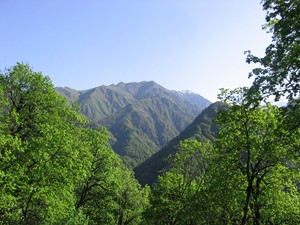
It is the result of the above-mentioned natural factors that Gabala region, which covers only 2% of the territory of the republic, attracts attention with its natural variety beginning from absinth and saline grasses of semidesert and desert plants up to moss and lichens, typical for mountain tundra nature, as well as xerophytes of dry steppes and different tree sorts of plains and mountain forests. The south part of the region is covered with absinth, semidesert saline vegetation and xerophyte rare forests, whereas in its central part (Alazan-Haftaran valley) the forests of oak, beech, hornbeam, as well as wing nut, alder, willow, poplar predominate forming plain forest landscape. Plain forests are gradually substituted with mountain forest zone and lasts until 1800-2000 m height.
Above the forest zone, from 1800-2000 m up to 2500-3000 m height subalpine and alpine meadows are replaced with rocky subnival and snowy –glacial nirel belt. Therefore, every tourist strolling about the nature of Gabala from the south to the north can observe the natural zones, which he could meet from the Mediterranean coasts to Africa approximately in 100-120 km distance. Forest coverage of the region is 60 thousand ha, it is 23.1 % of the total territory (Twice more than the same indicator in Azerbaijan). Forest cover of Gabala region, which is an integral part of the Caucasus forests that are distinguished with richness of vegetation cover and diversity of species, attracts attention with its fascination, colorfulness, and charm. Highly estimating natural beauty of these places, our national leader Heydar Aliyev proudly called Gabala “Azerbaijan’s Switzerland.”
Mountain and plain forests of Gabala are rich with endemic and relict plants, fruit and berry trees and bushes. Breech, oak, hornbeam, alder, wing nut, white-leafed, river poplar, willow, elm, cedar, birch, juniper, gum tree, chestnut, walnut, hazelnut and other trees and bushes can be stated as samples. 6 994 ha arid (droughty) forest landscape in Surkhaykhan mountains located between Turyanchay and Goychaychay, which was disjoined from Turyanchay national park in 1961 and was given under the control of Gabala forestry office, mainly consists of relict arjan, juniper, gum tree and wild pomegranate trees and bushes. In Alazan-Haftaran valley, alongside with wing nut, alder forests belonging to the III century, in 1975 iron tree wood land was discovered near Chukhur Gabala village which was formed naturally, and was called “Second Hirkan” of Azerbaijan. In 2002, a new areal of iron tree wood land (about 40 young trees) was discovered near Mammadaghali village.
A dense wood in Hamzali village formed by yew trees (250-300 years old), which is an only natural monument of Azerbaijan nature, attracted attention of the scientists not only from our country, but also the researchers from foreign countries. Valuable nutritious and medicinal plants as chestnut, walnut and hazelnut, as well as pear, apple, quince, medlar, cornel, alycha, haw, sea-buckthorn, sumach, dargil, wild raspberry and others are of great importance both in agriculture and in medicine. It also must be remarked that currant, lilac, sea-buckthorn, chestnut and cedar flowers which are distinguished for high content of nectar, as well as thyme, origanium, sarichop, locoweed, sainfoin, heracleum, rose and other flowering plants created wide possibilities for development of bee-keeping and folk medicine.
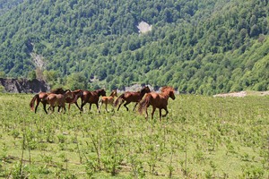
Depending on the natural landscape, forests and plains of the region are rich with different animal and bird species. Stag, mountain goat, mountain buffalo, roe deer, bear, wolf, lynx, European wild cat, squirrel, raccoon, fox, hog, rabbit, common hedgehog and porcupine and other animals, as well as Caucasian snowcock, spoonbill, pheasant, partridge, turaj, garden hen, wild dove, eagle, crow, also migrant birds as heron, stork, flamingo, duck and other inhabit here.
In steppe and plains, specially, in Gabala plateau, there live different species of reptiles, including “Tosik adder” which is known for its high quality venom. The south border of the region is adjacent with Turyanchay and the east border is adjacent with Ismayilli national parks. Besides it, in order to preserve magnificent nature of Gabala, Gabala state reserved area, covering 39 680 ha area encompassing Vandam, Damiraparan, Hamzali, Bum and Garachay basins, as well as Alvan valley, was established in 1993.
Agro climate
Foothill - hilly droughty region with warm agro climate – here refers the territory beginning from remote south areas of the region to the south foothills of Amilli-Kilsa Yengija-Gizlargalasi-Baylarkandi-Amirvan mountain ridges (transverse mountain range). The region of this agro climate encompasses entire Gabala plateau and Gash plain. The lowest annual average temperature of the weather in this territory is 0 0 and temperature difference between January and June months (annual t 0 amplitude) reaches +31 +45. Annual t 0 above 10 0 is equal to only 2600-3000 degree. Humidity coefficient of the weather is 0.15-0.25. The territory with such climate conditions is considered particular subtropical (Mediterranean marine type subtropics). It is similar to the agro climate of corresponding latitudes of Ajinohur plain and Aghdash region of our republic. At the result of researches it is determined that in such climate (particular subtropical) conditions it is possible to cultivate olive, pistachio, medlar, oleaster, bay-tree, grape, pomegranate, Caucasus date, quince, and partially feijoa and tea plants. Taking into consideration the condition of heat provision of plants in the above-mentioned region it is possible to get abundant harvest, cultivating fall wheat, tobacco, sunflower, corn for fodder, vegetable, grape, quince and pomegranate here. Grape gardens cultivated on 10 thousand ha area and abundant harvest obtained in this region (in Gash region, as well as around Gushlar, Savalan, Kurd, Mamayli, Bayramovka, Malikli, Bilikh and other villages) since 1978 up to the beginning of 1990 is an evident sample for it. For a long time this region was grain-growing region of Gabala.
II. Plain semiarid and semihumid warm Alazan – Ayrichay agro climate region – it begins from the north border of the first region and covers the above-mentioned valley from the west to the east (around Nij settlement, Mikhilgovag, Khirkhala- Mirzabayli- Soltannukha-Zaraghan-Tuntul-Seyidgishlag villages) in the direction of latitude. The lowest average indicator of temperature in this territory reaches – 12 0. Annual temperature amplitude is equal to 30-45 0 and humidity coefficient of the weather begins from semiaridity (0.25-0.35) and to the north changes to semihumidity (0.35-0.45). In connection with increase of the quantity of the lowest temperature and humidity in this region, in comparison with the previous region, there are suitable climate conditions here for growing fall wheat, tobacco, corn for fodder, rice paddy, vegetables (cabbage, tomato, cucumber, etc.), and dry fruits as walnut, hazelnut, chestnut, as well as juicy fruits as gizilahmadi apple, pear etc..Establishment of vegetable farms in Nij settlement and Mikhligovag village in 1970-80 years, as well as expansion of already existing orchards (hazelnut unions, walnut, and chestnut) at the end of 60th years were based namely on favorableness of natural conditions here.
III. Warm foothill and warmer than the medium level (mild-continental) humid Zagatala- Gabala region. The region of this agro climate begins from the north borders of the second region, passes the borders of Oghuz region and proceeds to the latitude where Abrikh-Tikanli-Bum-Hamzali-Gabala-Vandam populated areas are located and lasts until the borders of Ismayilli region. The lowest temperature in the region is equal to -120 - - 16 0. The difference between winter and summer temperatures is equal to 20-300. During a year active temperatures more than 10 reach 3361 in Gabala and 3200 in Vandam. In the region of this agro climate, it is possible to cultivate frigostable Caucasian date and medlar sorts, as well as walnut, hazelnut, chestnut, southern apple and pear sorts, peach and partially grape (unless it is protected from cold). The climate condition of the region is suitable for cultivating tobacco, corn, and fodder crops. The largest natural and cultural chestnut gardens of the region are located in the region of this agro climate.
IV. This is humid Ilisu-Lahij region, which is medium mountainous area and is provided with medium level of warmness. Its north border in Gabala passes through Gamaran-Laza latitudes. The lowest average temperature of the weather in the region is -16 0. Annual active temperature more than 10 0 reaches only 2000-26000. Humidity is similar to one in the third region. The agro climate condition of the region is suitable for cultivating fall wheat, potato, corn for fodder, walnut, and chestnut. Thick forests of Gabala is widely spread namely in the region of this agro climate.
V. The region of this agro climate is high mountainous area provided with warmness level less than norm. Here high annual temperatures more than 10 0 are equal to 800-2000. The climate type here, in Gumbashi-Aghbulag region where pasture areas of Gabala region refers, is humid mild-continental (20-30 0). Density and sorts of trees are decreased much in this region, which is located on high borders of mountain forests.
VI. This region, covering subalpine and alpine meadows, has soft continental (more than 20 0) and cold high-altitude agro climate (total amount of annual active temperatures more than 10 0 reaches 800 0). Economic significance of this region is characterized with good fodder deposits (summer pastures) for sheep breeding farms and with the main water recourses of the rivers running through the territory of the region. As it seems from the above stated classification, agro climate of Gabala region is very rich.
Each stated agro climate region enables cultivation of peculiar agriculture crops. It is sufficient to indicate one fact that ripening of fall wheat in Hajalli village and in Gabala city (30 km distance) has up to one month difference (20 VI in the south, 20.VII in the north). This fact also shows that it is possible to reap harvest twice in a year if to use reserve climate conditions in the south zone of the region and opportunities of long-term vegetation effectively. Mountainous relief, mineral waters of medicinal significance, rich and variable natural landscape, mountainous climate condition stated above, once again demonstrates reserve climate deposits of Gabala as a health resort. One of the unique features of the climate of Gabala is the fact that
60% of rainfall falls at nights, therefore daytimes are mostly clear, and sunny and it increases the resort and tourism opportunities.
Rivers
.JPG)
Relief and humid climate conditions of Gabala region led to formation of a thick river network in the area. The length of 486 rivers out of 8359 running in Azerbaijan territory is more than 10 km and 12 of them, as well as 2 of 23 rivers having the length more than 100 km are in Gabala. The rivers of the region refer to the left branches of Kura basin and runs directly into Kura or the rivers of Shirvan zone. Gara, Tikanli, Bum Hamzali, Damiraparan and Vandam rivers, which are the branches of Turyanchay and Goychay, have particular flow regime. According to the researches’ (S.Rustamov and B.Budagov) opinion, the rivers of this region refers to the group of rivers which make flood from snow water in spring and from rain water in autumn and pass 4 phases during a year. 40-50% of water supply of the rivers in the region is provided by subsoil waters, 25-30% by rainwater and 20-30% by snow water. Glacier and snow (a lake in Damiraparan) water play the main role in provision of Turyanchay and its branches, as well as upper streams of Damiraparan river. The period when the rivers have abundant water is March and July months and it forms 45-50% of annual flow. The lowest water expenditure is observed in August. Turyanchay running across the borders of Gabala and Oghuz regions takes its source from Ragdan (4020 m) peak and from the height of 3680 m in the southwest of Saral mountain range. Gara, Tikanli, Bum rivers which run in the territory of Gabala and which are left branches of Turyanchay, as well as their numerous tributaries (Aghchay, Bazarchay, Yatagchay etc.) join near Nij settlement and play great role in its becoming high-water. The length of Turyanchay, the name of which means wayward and tumultuous, is 180 km and flows into Kura river (in the territory of Zardab region) from – 4 height from the level of ocean. The area of its water storage basin is 1840 km² and it refers to the high-water group of rivers of Azerbaijan. Annual average water expenditure of Turyanchay is 18m3/sec and annual flow volume is 565 million m3.
Water, collected in Turyanchay, in the areas located in the west of the regional centre, in the south of Beyli village (in the west of Savalan) together with the branch separated from Damiraparan and joining with Garachay tributary, which has abundant water, caused expansion of the riverbed and growth of water twice. By means of the channels separated from Turyanchay water junction constructed in the passage called Chayboghazi, the water of this river is widely used in irrigation of the sown areas of Aghdash and Goychay regions. Goychay river, the second largest river of the region, forms a natural border with Ismayilli region along the eastern border of Gabala. Goychay river, taking its source from the western foot of Baba dagh mountain (3632 m) and from the height of 1980 m, runs for 133 km and joins to Kura river on the height of 21 m in the territory of Ujar region. Goychay river, water-storing area of which is 1170 km², feeds from subsoil, rain, and snow water. Average annual water expenditure is 12.5 m/sec and its annual flow volume is equal to 394.2 million m3. Water of Vandam river (it is called Tapalar or Garachay in the south of the region) which takes its source from the eastern foot of Tufandagh mountain (4191 m) in Gabala region and Damiraparan river (it is called Gobuchay or Zalam gobusu in the south) (right branches of Goychay river) plays main role in supply of Goychay river. Damirapran river which runs through the central part of the region and is distinguished with its powerful torrents takes its source from the south slope of the Great Caucasus on 3850 m height from ocean level. It runs for 90 km and is called “Zalam Gobusu” in Gabala plateau. It joins to Goychay river on 385 m height in the west east part of Bayramovka village. Arpali, Aghnulag, Tufan, Sangar, Mujug, Durja and other tributaries in the source part of Damiraparan river feeds from snow and glacier water, as well as from a number of mountain lakes in subsoil and surface forms. Water collecting area of Damiraparan river is 596 km². The river is divided into two branches in the north of Gabala city. The main branch of the river running in the east of the city is called Damiraparan and the one running in the west is called Garachay. In the south this branch joins into Hamzali river and then to Mirzabayli, Gojalan and other small rivers and again is called Garachay. Running along the east of Dizakhli village, it further joins to Turyanchay in “chaygovshagi” (“river joint”) (in the north of Savalan village). So Damiraparan river can be called “bordering” river between basins of Turyanchay and Goychay.
Bum, Hamzali and Vandam rivers, which are branches of Turyanchay and Goychay rivers are also distinguished from the above-mentioned rivers with abundance of water and their length.
The territory of the region is divided into three zones according to the density of the river network;
1) Rivers of the mountainous zone distinguished with more dense river network and feeding from snow-glacier, lake, rain and subsoil water. This zone forms source part of the rivers in the region. At the result of a swift current and bottom erosion, formation of deep canyon-shaped river valleys and waterfalls is characteristic for the main rivers and their tributaries in this area. Muchug waterfall on Muchugchay river, which is the left branch of Damiraparan river, ranks second in Azerbaijan after Afurcha waterfall on Valval river basin of Guba region for its height (50 m). Waterfalls on upper streams of Vandamchay, Durchachay, Hamzali and Bum rivers attract attention for their fascinating view.
2) The rivers, distinguished with medium level of density, running across Alazan-Haftaran valley. Here, speed of mountain rivers weakens, lateral erosion intensifies and fragments of materials (stone, pebble, sand) get accumulated in the river bed filling it, at the result of which the river forces to change its direction to different directions. The rivers in the above-mentioned valley feed from subsoil waters close to surface, springs and bogs (60-70%), rainwater (20%) and partially snow (10%).
3) The rivers running across Sheki-Gabala plateau which is distinguished with weak density. As this area have dry mountain-plain climate conditions, it is possible to say that no particular river is formed here. The rivers beginning from the north areas form deep ravine and gorge network here.
While speaking about the rivers of the region, one must stress out flood events happening in these rivers. The word “flood” is called with up to 50 names by a number of world nations. In Alp mountains it is called “ruff”, “nant”, “kish”, Germans call it “mur”, in Central Asia it is called “sil” and in Caucasus it is called “sel”, “seyl”, “selvav” and “sellab”. The notion of “sel” used by the Caucasian nations is of the word “sey” of Arabic origin and means raging water torrent overflowing the surroundings. Generally, the concept of flood is determined in our republic as “water torrent running from mountain slopes in a very high speed and bringing a lot of stone, pebble, sand, clay etc. with it and having a destructive power.” The main difference of the flood from abundant water is its source, as well as high quantity of dependant materials in its content. Usually in the floods happening in the rivers of our region, which are distinguished with stony and muddy floods, only 20-30% of the flood is water, whereas 70-80% of it consists of stone, sand, pebble etc. Such a mass often cannot form a whole stream along the riverbed and consisting of separate coils (as the shape of clew) moves by the power of internal strength. These slopes which are called “Sel gefili” (“Unexpected flood”) hit against hard obstruction and at this time rendering great noise and illumination wraps all surroundings into stones, sand and silt. Most of the people observing such a flood running through Damiraparan river in 13-16 August, 1997 and 22-25 November, 2002, called it “Volcano lava”.
Researchers have determined that the south-west slope of Great Caucasus, where our region is located, for its flood level, shares the same rate with Hwang Ho, Chang Jiang (China), Po (Italy) and other rivers which are known in the planet for their destructive floods. According to spread of floods, our republic is divided into three regions, consequently, the region with the strongest floods, the region with floods of medium severity and weak flood zone. Western part of Gabala region, the basin of Tikanli Gara (Turyanchay) river refers to the region with the strongest floods; the remaining area refers to the zone with floods of medium severity. At the result of conducted researches, it was determined that in Gara-Tikanli Bum, Hamzali, Damirapran rivers, including Kish and Shin rivers running across Sheki region, there happened more than 50 very destructive floods during 360 years and it forms 30% of all destructive floods took place in Azerbaijan at that time. The strongest floods in Gabala region happened in the second part of the XIX and the first part of XX century. It is enough to note just one fact that in recent 100 years (1899-1999) there were 14 very strong floods in Damiraparan river. The flood, took place in Damirapran river on August 9, 1899 lasted for several hours and completely destroyed Gutgashen village (present Gabala city). It is interesting that, floods, which are one of rhythmical events of the nature repeats every 100 years. Destructive floods happened in Damiraparan river in 1973, 2001 and 2002 inflicted much harm and losses to the populated areas, orchards and social objects located in the east part of Gabala city. The most destructive floods in Tikanli, Bum and Hamzali rivers took place in 1933, 1934, 1935, 1945, 1948, 1952 and the late years of the XX century. At the result of the flood happened in Tikanli river on July 1, 1945, there was a great destruction between Tikanli and Mikhligovag villages and Mikhligovag village was completely destructed. The result of the damages inflicted to yards, gardens and orchards, as well as to sown areas, caused by this flood, which had 2.5 m height and lasted for 3.5 hours still remains. During destructions took place in Turyanchay in June-July months of 2002, a part of Zaraghan-Aghdash motor road located on the left bank of the river in the south of Savalan village fell at risk of destruction. Powerful flood torrent came into left branch of Bum river and ran into Gamarvan village In July, 2006 and inflicted much harm to this populated area.
As stated above, flood is one of the most destructive natural disasters happening in the nature. At present time, the reasons of such a disaster and the ways of preventing it have already been determined. Nowadays in the rivers of the region, dams are being constructed for protection from the floods.
The main factor leading to flood is: rocks inclined to erosion are disposed to dry frost during long winter and pasturing cattle in spring and summer speeds up the erosion, preparing “flood materials.” Flood also occurs at the result of abundant downpour on mountain slopes and riverbeds.
In order to prevent flood, natural forests, and bushes on mountain slopes must be well preserved and plateaus should be used as pastures in a sequence and forest zones should be formed on the banks of the rivers running near the populated areas. A forest zone called “Ruh meshesi” (‘Soul forest’) established in the north of Gabala city between Damiraparan and Garachay river, protects Gabala from destructive floods for 100 years already. Natural struggle referring to titrometric measures system is cheap from economical point of view, as well as decreases the risk of flood much.
Another way of protection from the flood carried out by people is building stone-wood and stone-concrete dams on the banks of the rivers near of which populated areas, sown areas, gardens and other objects are located. Until 1956, building stone-wood dams in the basin of rivers with a risk of flood was the main direction. Beginning from 1950-1960 years unstable and short –term stone-wood dams were replaced with stone-concrete ones. Therefore, concrete dams were constructed in Tikanli, Bum, Damiraparan, Vandam, Turyan rivers of the region. In recent years, great attention is given to construction and quality of stone concrete dams in above-mentioned rivers with flood risk in order to prevent damages that can occur at the result of flood.
Lakes
 The territory of Gabala region is rich with mountain lakes. A prominent pedagogue Rashid Bey Afandiyev teaching in Gutgashin school (present Gabala secondary school № 1) in 1882-1890 got interested in the lakes of this region and published an article under the name of “Nohur golu” (“Nohur lake”).
In 1935 limnologist A.H.Alizada and in 1960 R.B.Tarverdiyev and Kh.S.Zamanov investigated the lakes of Great Caucasus, including the lakes of Gabala region.
Majority of the lakes in the territory of Gabala region are located in Damiraparan river basin on 2300-3380 height from the ocean level. Number of such lakes, located in the cavities and intermountain troughs made by mountain glaciers (of glacier origin) in the IV period of glaciation, are about 10. In high-water period, their area changes between 0.1-3.8 ha. The main lakes which feed Damiraparan river and its branches are the followings:
Tufanghol- is located on 3 277 m height from the sea level, 4 km in the north from the left branch of Tufanchay, which is the left tributary of Damiraparan river. Tufanghol, which is a lake of moraine origin, is surrounded with mountains. It is a lake of fresh water fed with snow and glacier waters. The length of the lake is 160 m, the width is 125 m, and total area in high-water period reaches to 3.8 ha. The water of Tufanghol, the depth of which is about 5.6 m, is transparent in summer months and the bottom of the lake until 2 m is clearly seen. The temperature of the water in the lake is more than +10 0 in July. The weather in the surrounding area of Tufanghol, which is located in the north border of the mountain plateaus of the region, is cloudy, snowy, and stormy for 8-9 months. Sometimes snow cover remains unthawed during all year round. Nomadic cattle-breeders (local people), who know these places well, call Tufanghol ‘Nuhun golu’ (‘Noah's lake”).
According to the legend, the broken fragments of Noah’s ark were met on the shore of this lake. But the names of Tufan dagh (‘Stormy mountain’),”Tufan chay” (“Stormy river”) and “Tufan ghol” (“Stormy lake”) most likely are related with severe, stormy, windy nature of this territory.
Ismayil Bey Gutgachinli lake – it is located on 3 305 m height from the sea level, 4 km in the north of Tufanghol, 3 km in the north from the source of the left branch of Damiraparan river. The lake is located on the mountain height. This lake, the total area of which is 1.3 ha, feeds from snow water and from the abundant-water spring located nearby. No river begins from this lake.
However, the water of the lake flows into the tributary of Damiraparan river by means of subsoil fissures. As this lake was without a name, the investigators gave the name of Haji Ismayil Bey Gutgachinli (1806-1869) in 1961, who was a local writer and prominent military leader promoted up to major general rank for his services in military field, to this lake.
It must be remarked that formerly tsarist Russia presented the area, where this lake is located, to Ismayil Bey Gutgahinli for his services.
Kulak ghol – it is located on 3 380 m height (It is the highest lake in the region), 1 km in the west of I.B.Gutgachinli lake. The length of the lake is 145 mm, the width is 110 m and the total area of it in high-water period reaches to 3.6 ha (in low-water period it is 2 ha). Besides subsoil waters of nearby, the lake also feeds from snow water. There are also five nameless lakes with the area of about 0.1 ha, around Kulak ghol. In 50 m to the north of Kulak ghol there is a wide snow “glade” with the area of more than 1000 m² and about 5 m thickness and when snow thaws here a lot of water (21/sec) flows into nearby lakes.
Gotur ghol- (“Itch lake”) it is located on 2 340 m height from the sea level, on the closed intermontane lowland in the source part of Arpali river, which is the left branch of Damiraparan river. From the northeast direction, a small river flows into the lake.
Gotur ghol is a running water pond. From the west direction, the left branch of Arpachay takes its source from this lake. To investigators’ opinion, by building dam before the lake, Gotur ghol, which has stable feeding sources, can be used as water storage for household purposes. The origin of the geographical name given to the lake is related with the fact that because of medicinal peculiarities, the water of this lake is used by the local people in prevention of mange disease met among sheep.
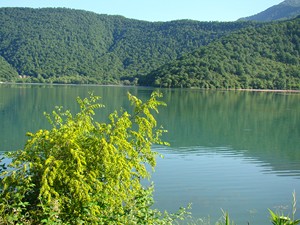
Nohur lake – (Nohurgishlag water storage) – It is located on 700 m height from the sea level in a natural groove among Gulluburun, Goydagh and Yumuru mountains, 3 km in the east of Gabala city, 1 km in the north of Nohurgishlag village. Nohur ghol which existed as a natural lake until 1949, used to be surrounded by a swamp covered with dense reeds and water plants and there was a lake with yellowish-green water in a deep groove in the central part of it. In 1949, by building a soil dam with 850 m length, 8-10 m height and 4-6 m width, a water-storage reservoir was constructed in the south part of this lake (between Gulluburun and Yumuru mountains).
The length of the water-storage reservoir at present time is 1925 m, width is 1355 m and its total area is 240 ha. Maximum depth reaches 24 m and volume of the water is about 16 million m3. Water of Damiraparan (70%) and Vandam (30%) rivers is spilt into Nohurgishlag water-storage reservoir. Besides refining the water of the above stated rivers, Nohurgishlag water-storage reservoir has a great significance in meeting needs for water of agriculture of Gabala, Aghdash, Goychay and Ujar regions.
From another point of view, this water-storing place at the dense populated area located at Gabala-Ismayilli-Baku motor way is one of the resting zones most visited by the tourists and guests. Nohurgishlag water-storage reservoir has also a great contribution to the development of aquaculture and rowing sport. In winter of 1953, thickness of the ice cover on the surface of the lake reached 40-50 cm. In winter months of 2007, 2008 and 2011 complete icing of Nohurgishlag water-storage reservoir took place.
In 1970-1980 years, small water storages were set up in the west zone of the region around Kondalandagh mountain and in the basin of Bum and Hamzali rivers. Such water storages were also established in the south of Khirkhatala village- 1 km in the north of Gabala Sheki motor way, on Hamzali river, on Jovurlu river in the junction of Mirzabayli and Soltannukha villages , on Gajalan river in the south of Tola village and in the south of Bayramovka village (“Ulam”). However some of them are now out of service because the soil dams have already been washed out.
In order to provide the agriculture of Sheki-Gabala plateau of the region with irrigation, “Yenikand” channel from Vandam river, “Amili” channel from Damiraparan river, “Kurd” channel from Gojalan river and “Tosik” channel from Dizakhli (Gara) river have been constructed around the villages of the same names.
Gabala region ranks first in Azerbaijan for the volume of mountain glaciers. Almost all mountain glaciers existing in Azerbaijan territory of Great Caucasus are in the northern borders of the region. Conducted observations showed that the area of mountain glaciers existing in our republic is reduced from 10 km ² to 6.6 km² in recent 70 years. 6.2 km² of it is located approximately on 3600-4000 height in the borders of Gabala. Area of glacial zones feeding the rivers running in the territory of the region is 3.6 km² in Bazar duzu peak (4466 m), 1 km² in Bazaryurd peak (4126 m), 0.5 km² in Tufandagh (4206 m) and 1.1 km ² in Shahdagh peak (4243 m).
Above stated mountain glaciers located in the water collection basin of Gara, Tikanli, Bum (the branches of Turyanchay river), Damirapran and Vandam rivers play a great role in feeding of these rivers. Role of some branches of Damiraparan and Bum rivers in feeding from mountain glaciers is 60-70%. However, the water of the rivers in the region is formed from 40-50% subsoil water, 25-30% of rainwater, and 20-30% of snow and glacier water.
13% or 0.51 km3 of fresh water reserves (3 873 km3) of Great Caucasus natural region are in Gabala region and 29 million m3 of it is formed from subsoil water. As indicated in scientific literature, subsoil waters of Gabala are divided into ground and artesian waters. At the result of steepness of the slopes and destruction of deep river valleys in the north mountainous part of the region, ground waters come out to the surface in the form of springs and fountains. As stated above, Alazan-Haftaran valley coincides with breakage of Great Caucasus tectonic rise and Kura tectonic basin, and for this reason, it is rich with ground waters and with high-pressure interlaminar waters. While the level of ground waters in the north part of the valley is 70-100 m, this indicator in the latitude connecting Nij settlement, Chukhur Gabala – Soltannukha- Yengija -Mammadaghili villages is 0 meter and ground waters in most places come out to the surface with abundant fountains or form a bog.
The level of ground waters falls down in Hajalli –Malikli plains of Sheki-Gabala and in the territories of the plateau, bordering with Surkhaykhan mountains, it again comes closer to the surface and forms springs.
If we compile a catalogue of natural springs existing in the region, their number would be more than 1000. There is no village, nor a populated area in the region, particularly located in the north of Kondalandagh (Amilli-Sirtyengija-Amirvan mountain ranges), near of which there would not be tens of springs. The information about the most popular mineral waters of the region is given above. In the table below you can have information on a group of springs well-known for the quality of the water.
The territory of Gabala region is rich with interlaminar high-pressure waters. From this aspect, the south of Great Caucasus where the region is located ranks third after Kur-Araz, Samur-Davachi artesian basins. The growth of population in the region and consequently, growth of need for fresh water necessitates usage of interlaminar high-pressure waters more and more.
If in 1970-80 years, there were artesian wells only in some places, now there are more than 260 such wells over the region. Artesian wells in Gabala city, Nij settlement, Vandam, Zaraghan, Boyuk Piralli, Hajalli, Dizakhli, Kurd, Sirt yengija, Yengija, Nohurgishlag, Tuntul and other villages play great role in meeting the need of population for fresh water, and even need for cattle-breeding and household works.
As stated above, surface (rivers, lakes, water storages, and glaciers) and subsoil waters of Gabala region has great importance for agriculture. Speedy mountain rivers in the territory of the region, besides being fresh water source for the population and its agricultural needs, also have a great hydroelectric potential. Even in 1953, the resident of Nij settlement called Dallari made the first hydroelectric device on the river running across the village and at that time, the electricity given by this station was used for illumination of houses and for other household needs.
In 1956, a trout rearing station was established in the juncture of Jovurlu and Gara rivers in the northeast of Chukhur Gabala village and in recent years, 100 millions of valuable baby fish was spilled into the Caspian Sea by means of Kura river and it functioned as a valuable enterprise for providing the Caspian sea with fish recourses. Today there are very suitable hydro-biological natural conditions for rearing of golden carp, which is dying species, in fresh water basins of Gabala region. Beside all these, subsoil and surface waters of the region are of great importance for meeting the needs of the population for fresh water and its usage in agriculture not only in Gabala region, but also of neighboring Aghdash, Goychay, Ujar and Zardab regions. In order to use rich artesian waters of Gabala and Oghuz region in solving the fresh water problem of Baku city, the foundation of Oghuz-Gabala-Baku water line was set up on March 1, 2007 under the leadership and with the participation of the President of Azerbaijan Republic Ilham Aliyev and on December 28, 2010 there was an opening ceremony of Oghuz-Gabala-Baku water line. The author of the initiation of bringing high-quality fresh water of Oghuz and Gabala regions to Baku belongs to our national leader Heydar Aliyev. The president of our country and worthy successor of our national leader Ilham Aliyev took significant steps in realization of this project, which is one of the biggest infrastructure projects of Azerbaijan. The foundation of this project was laid down in March 2007 in Sinjan village of Oghuz region and thus, construction works began. In order to provide this water line, the length of which is 262 km, with water, a lot of artesian wells were set up and substations were established. In the territory of Oghuz region the complex of main water receiving devices was built on 417 meter height from the sea level and at the same time, many regulating devices for water purification were constructed on the line. The president of Azerbaijan Republic Ilham Aliyev participated in the opening ceremony of Oghuz-Gabala-Baku water line.